

As Hurricane Otis made landfall in Acapulco, Mexico, on Wednesday, October 25, as a Category 5 hurricane with 165 mph sustained winds, a wind gust of 205 mph (330 kph, or 91.6 m/s) was recorded at the port authority at Acapulco Bay. If verified, this would be one of the top 15 strongest wind gusts ever recorded globally by a ground-based instrument. Sustained winds for hurricanes in the Atlantic and Eastern Pacific are typically averaged across one minute, whereas a wind gust may last as little as three seconds. Wind gusts in hurricanes are normally assumed to be about 20% stronger than sustained winds, but gust strength can vary widely.
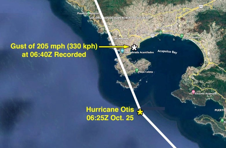

On Monday, officials of the Mexican National Tidal Service (Servicio Mareográfico Nacional del Instituto de Geofísica) posted a thread on X discussing data taken by one of their instruments in the right-front eyewall of Otis, exactly where one would expect the strongest winds to occur. The instrument recorded a sustained wind of 114 mph, gusting to 205 mph (183 kph, gusting to 330 kph), at 12:40 a.m. CST (06:40Z) on October 25, 15 minutes after the National Hurricane Center said Otis made landfall with sustained winds of 165 mph (266 kph). Sustained hurricane-force winds of at least 74 mph (119 kph) occurred at the station for about 40 minutes. The maximum storm surge of 1.5 feet (45 cm) occurred as low tide was approaching; the lowest pressure was 963.5 mb.
Before and after photos of the site showed that the measurement was taken by a sonic anemometer on a tower. However, the tower appeared to be considerably lower than the 10-meter standard height used for wind measurement — perhaps only half that height — so the winds measured would have been slowed by surface friction. The exposure of the site appears good: The tower was located near the end of a pier, with no major buildings or obstacles obstructing the flow. The sonic anemometers at the site used sound waves to make its measurement, and this type of measurement can be affected by heavy rain.

The top 15 highest wind gusts on record
Measurement of extreme wind gusts in the 200-mph range from surface-based towers is extremely difficult. Winds that strong usually destroy the equipment or disable communications, and the winds typically carry intense precipitation and flying debris that can affect the measurement. Only about 15 measurements of wind gusts in excess of 190 mph that are not obviously flawed exist; many of these measurements have limited documentation and should be viewed with considerable skepticism. Even well-documented extreme wind gust measurements should be viewed with some skepticism. This is even true of the official world record-holder: a 253 mph (113.2 m/s) gust recorded in Cyclone Olivia on April 4, 1996, on Barrow Island, Australia. This measurement underwent a detailed investigation by a World Meteorological Organization committee that deemed it valid. But in a paper presented at the 2013 16th Australasian Wind Engineering Society Workshop, J.D. Holmes and L. Noicos argued that the anemometer mast used would have likely buckled in a wind gust in excess of 172 mph (77 m/s) and that the actual peak wind gust during the typhoon was only 150 mph (67 m/s) — more than 100 mph below the official reading.
It’s also worth noting that winds atop hills or mountains will often be significantly higher than those measured on flat terrain. In a series of papers published in the journal Boundary-Layer Meteorology in the mid-1980s, mean wind speed-ups of the order of 90% (almost a doubling) were observed on the crest of Askervein Hill in Scotland when compared to the mean wind speed measured simultaneously at a reference station located on flat terrain upstream of the hill. Askervein Hill was a relatively low-slope topographic feature that only rose 381 feet (116 meters) above the surrounding terrain. Thanks go to Craig Miller of the University of Western Ontario for this insight.
With these caveats in mind, above is a top-16 list of official and unofficial wind gusts recorded worldwide. The list comes courtesy of similar lists compiled by Jim Yang on X in October 2023 and by Chris Burt in a 2020 blog post at wunderground.com, “The Highest Anemometer-Measured Wind Speeds on Earth.” Note that the Taiwanese island of Lanyu holds three of the top spots on this list; measurements at that site occur on top of a hill of elevation 325 meters (1,066 feet), which presumably experiences acceleration of the winds as described above — as do all of the measurements taken on the various mountains that appear on the top-16 list. Strikingly, two of the top-16 wind gusts in world history (highlighted in red) were measured last month — in Taiwan on October 4 during Typhoon Koinu and in Acapulco on October 25 during Hurricane Otis.
Bob Henson contributed to this post, and thanks go to Bruce Harper for his helpful suggestions.
Website visitors can comment on “Eye on the Storm” posts (see comments policy below). Sign up to receive notices of new postings here.


