

Monday was a notably busy October 23 for the world’s cyclone-producing tropical ocean basins. The day kicked off with six tropical cyclones churning across the Atlantic, Eastern Pacific, Southwest Pacific, North Indian, and North Arabian seas; only the Northwest Pacific and South Indian oceans were tropical cyclone-free. According to Colorado State University, all of the Northern Hemisphere basins are running above average for accumulated cyclone energy for 2023 thus far — a reflection of how record-warm ocean temperatures over much of the planet have overpowered the normal tendency for some basins to have active years while others are less busy. Of particular note was Cyclone Lola in the southeastern Pacific, which was the earliest Category 4 storm ever observed in that ocean basin’s season, which runs from November to April.
Hurricane Tammy swings into the open Northwest Atlantic
After plowing along the eastern side of the Leeward Islands over the weekend, and making landfall on Barbuda (population 1,600) as a Category 1 storm with 85 mph winds on Saturday night, Hurricane Tammy is now pulling away from the islands to the north.
At 11 a.m. EDT Monday, Tammy was located about 260 miles north of Anguilla in the Leeward Islands, headed north at 7 mph with top sustained winds of 80 mph and a central pressure of 993 mb. Satellite images early Monday afternoon continued to show the effects of moderate wind shear of 10-20 knots out of the southwest, which kept Tammy’s heaviest rains and strongest winds more to the northeast side of the storm. There were no watches or warnings for the islands in effect, though the northern Leeward Islands, Virgin Islands, and Puerto Rico were predicted to experience periodic heavy rains on Monday from Tammy’s southernmost spiral band.
Hurricane Tammy forecast
Conditions will be favorable for some modest intensification of Tammy over the next two days, with moderate to high wind shear of 15-25 knots, a reasonably moist atmosphere, and record-warm waters of 29 degrees Celsius (84°F), about one to two degrees Celsius (1.8-3.6°F) above average. By Wednesday, increasing wind shear and dry air from a trough of low pressure to the west will likely induce weakening, and the National Hurricane Center predicts that Tammy will become a post-tropical storm with 70 mph winds on Thursday. On Saturday, the post-tropical storm Tammy will likely be angling westward, perhaps passing close enough to Bermuda to bring tropical storm conditions to the island. A number of ensemble members from the European and GFS models bring Tammy’s remnants westward toward Florida from the weekend into early next week, which would be an unusual outcome indeed for late October.
Invest 95L bringing heavy rains to Nicaragua and Honduras
An area of disturbed weather off the Atlantic coast of Nicaragua, designated Invest 95L by the National Hurricane Center, was headed northwest at about five mph early Monday afternoon. Satellite images showed that 95L was close to tropical depression status, with a surface circulation that was becoming more defined and heavy thunderstorm activity that was growing more intense and more organized. The disturbance is expected to move inland over Nicaragua south of the Honduras border on Tuesday morning, and will likely bring rains of four to eight inches to eastern portions of Nicaragua and Honduras over the next three days, which will be capable of causing dangerous flooding and mudslides. In their 8 a.m. EDT Tropical Weather Outlook, the National Hurricane Center gave 95L two-day and seven-day odds of development of 60%. 95L is not expected to reach tropical storm strength, but if it did, its name would be Vince.

Mexico’s twin threats: Norma dissipates as Otis gathers strength
Former Hurricane Norma was designated a remnant low at 11 a.m. EDT Monday, its moisture and circulation wrung out against the rugged terrain of Mexico’s Sierra Madre Occidental range. Norma made landfall as a Category 1 hurricane just northwest of Cabo San Lucas on Saturday afternoon. Norma’s rains triggered widespread flooding in southern Baja California, closing the airports at La Paz and Cabo San Lucas, but no major damage or serious injuries had been reported by the Associated Press as of Monday morning.
Norma crossed Baja California and the Gulf of California over the weekend and made a second Mexican landfall at around 6:30 a.m. EDT Monday morning as a tropical depression in the state of Sinaloa, roughly midway between Los Mochis and Mazatlan. Showers and thunderstorms raced inland late Sunday ahead of Norma’s lagging, weakening surface circulation, but only a few showers remained near Norma’s center by early Monday.
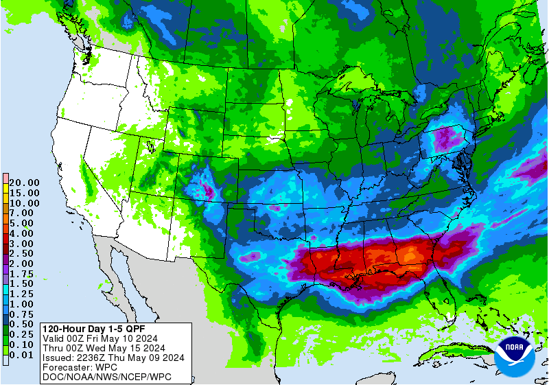
An expansive slug of upper-level moisture extended from Norma’s remnants across northwest Mexico and over much of Oklahoma and Texas. As this moisture intersects low-level flow from the Gulf of Mexico, widespread rains will drench the drought-stricken Southern Plains. The upper low steering Norma inland will itself move through Texas and Oklahoma by midweek, bringing additional rains. By week’s end, one to three inches can be expected along a frontal corridor from West Texas to Upper Michigan, and localized totals could top four inches in the Southern Plains and Upper Midwest, helping ease drought conditions that have been expanding across the central U.S.

On the heels of Norma, Mexico will be dealing with Tropical Storm Otis, which formed on Sunday afternoon off the coast of southern Mexico. As of 11 a.m. EDT Monday, Otis was centered about 375 miles south-southeast of Acapulco, moving north-northwest at about 7 mph. Top sustained winds were 45 mph. A Tropical Storm Watch was in effect for the coasts of Guerrero and Oaxaca states from Lagunas de Chacahua to Tecpan de Galeana, including the Acapulco area.
Otis is in a moist environment (midlevel relative humidity around 70-75%) and will be moving over toasty waters, with sea surface temperatures increasing from around 28 degrees Celsius (82 degrees Fahrenheit) to around 30 degrees Celsius (86°F) along the storm’s path. Moderate southerly wind shear of 10-20 knots will tap the brakes on Otis to some extent and strengthening is predicted to be gradual rather than rapid. Otis is predicted to continue north-northwest and to approach the coast by Wednesday as a strong tropical storm, though it would not be a surprise if Otis attained Category 1 strength by that point. Models disagree on whether Otis will move bodily inland or linger off the coast for one or more days. In either case, heavy rains could affect coastal areas for a prolonged period.
Tropical Cyclone Tej bringing dangerous rains to Yemen and Oman
A weakening Tropical Cyclone Tej was about to make landfall in Yemen near the Oman border on Monday afternoon as a Category 1 storm with 85 mph winds, according to the 8 a.m. EDT Monday advisory from the Joint Typhoon Warning Center. The India Meteorology Department predicted that Tej would make landfall near Al Ghaidah, Yemen, between 18-21 UTC Monday, with sustained three-minute-average winds of 80-85 mph. A storm surge of up to two meters (6.6 feet) was predicted near and to the right of the landfall location. Neither the Joint Typhoon Warning Center nor the India Meteorology Department gave a rainfall forecast for Tej, but the 6Z Monday run of the GFS model predicted rainfall amounts exceeding 500 mm (about 20 inches) along the coast of Yemen near and to the right of the landfall location. While this forecast is probably too high, even rains in excess of two inches in this desert region, which normally receives only about two inches of annual rainfall, will cause dangerous flash flooding and mudslides.

Tej tied as seventh-strongest Arabian Sea cyclone on record
Tropical Cyclone Tej reached peak intensity as a high-end Category 3 storm with 125 mph winds at 18 UTC, October 22, according to the Joint Typhoon Warning Center. This makes Tej tied for seventh-strongest tropical cyclone on record in the Northern Indian Ocean’s Arabian Sea. The Joint Typhoon Warning Center does not assign landfall intensities, but if one considers the six-hourly advisory before landfall (or at landfall), Tej will not rank as a top-five strongest landfalling Arabian Sea cyclone on record. The top five, according to the Joint Typhoon Warning Center (available at the NOAA Historical Hurricane Tracks database):
1. 125 mph, May 20, 1999, Cyclone 02A/ARB 01, Gujarat State, India
1. 125 mph, May 17, 2021, Cyclone Tauktae, Gujarat State, India
3. 120 mph, June 3, 2010, Cyclone Phet, Oman
3. 120 mph, June 9, 1998, Cyclone 03A/ARB 02, Gujarat State, India
5. 105 mph, June 6, 2007, Cyclone Gonu, Oman
Climate change is increasing threat of powerful Arabian Sea tropical cyclones
The North Indian Ocean has two tropical cyclone seasons — one centered in May, before the onset of the monsoon, and one centered in October/November, after the monsoon has waned. During the June-September peak of the monsoon, tropical cyclones are uncommon because of interference from the monsoon circulation. Since the introduction of reliable satellite data in 1998 over the Indian Ocean, no Category 4 or stronger cyclones were observed in the Arabian Sea until 2007. Now, there have been six such storms, with Tej just missing that mark.
This unprecedented shift in tropical cyclone activity led to a 2017 modeling study that concluded that human-caused climate change had increased the probability of powerful tropical cyclones over the Arabian Sea during the post-monsoon period (October/November) and that this risk would increase further in the future — with potentially damaging consequences to the nations bordering the Arabian Sea. In a 2018 review paper (“Tropical Cyclones and Climate Change Assessment: Part I. Detection and Attribution“), all 11 hurricane-scientist authors concluded that the balance of evidence suggests that there was a detectable increase in post-monsoon extremely severe cyclonic storms in the Arabian Sea during the 1998–2015 period; eight of 11 authors concluded that human-caused climate change contributed to the increase. Ten of 11 authors of the 2018 review paper concluded that the balance of evidence suggests that there is a detectable increase in the worldwide average intensity of global hurricanes since the early 1980s. Eight of the 11 authors concluded that human-caused climate change contributed to that increase.
Tropical Cyclone 06B in the Bay of Bengal forms
Tropical Cyclone 06B formed on Monday morning in the North Indian Ocean’s Bay of Bengal and was bringing heavy rains to the coasts of India, Bangladesh, and Myanmar. At 12Z (8 a.m. EDT) Monday, 06B was a tropical storm with top sustained winds of 45 mph, headed north-northeast at 12 mph. The Joint Typhoon Warning Center predicted that after a short period of intensification Monday, high wind shear would rapidly weaken the storm to a depression by Tuesday, with landfall occurring Wednesday in Bangladesh. The India Meteorology Department predicted that Tropical Cyclone 06B would bring a storm surge of 1-1.5 meters to the coast.
Record-breaking Category 4 Cyclone Lola forms in the southeastern Pacific
In the southeastern Pacific, Tropical Cyclone Lola rapidly intensified into a Category 4 storm with 130 mph winds on Monday morning, its winds increasing by 65 mph in just 24 hours, according to the Joint Typhoon Warning Center. Category 4 cyclones are extremely rare this early in the season in the Southern Hemisphere, whose tropical cyclone season runs November through April. Lola is the second-earliest Cat 4 ever observed in the Southern Hemisphere and is the earliest ever observed in the southeastern Pacific. The only other October Cat 4 in the southeastern Pacific was Cyclone Xavier of 2006, which became a Cat 4 with 130 mph winds and a central pressure of 927 mb on October 24, 2006. The earliest Cat 4 on record in the Southern Hemisphere was Cyclone Anais in the South Indian Ocean on October 14-15, 2012, also with 130 mph winds.
A September 2023 study published in the prestigious journal Nature, Seasonal advance of intense tropical cyclones in a warming climate, found that there has been a significant seasonal advance of Category 3 and stronger tropical cyclones since the 1980s in most tropical oceans, with earlier-shifting rates of 3.7 and 3.2 days per decade for the Northern and Southern Hemispheres, respectively. The authors blamed the earlier shift on human-caused emission of heat-trapping gases.
Forecast for Lola
Lola has light wind shear of 0-5 knots and warm waters of 28-29 degrees Celsius (82-84°F), which may allow some additional intensification on Monday. If Lola does intensify further, it will be the strongest Southern Hemisphere tropical cyclone ever observed so early in the season. By Tuesday, steering currents are expected to take Lola on a southwesterly track that will take the storm through the Vanuatu Islands. Increased wind shear is predicted to cause rapid weakening, with Lola passing through the islands as a Cat 2, weakening to a Cat 1.
Website visitors can comment on “Eye on the Storm” posts (see comments policy below). Sign up to receive notices of new postings here.